We were headed for an afternoon on the Salmon River
Trail #42 out of Welches, Oregon. Even getting there was magnificent. The
beauty began soon after leaving the mountain town of Sandy. It was June and the
snow was still covering most of Mount Hood. The wildflowers were in bloom. It
was a perfect day for hiking.
Driving to the Salmon
River
In Welches, we took the Salmon River Road. We were shaded by the forest canopy on this increasingly warm day. Five miles of narrow, pot-holed road but who cares when it is bordered with beautiful blue, purple, pink and white wildflowers.
In Welches, we took the Salmon River Road. We were shaded by the forest canopy on this increasingly warm day. Five miles of narrow, pot-holed road but who cares when it is bordered with beautiful blue, purple, pink and white wildflowers.
We entered the Mt. Hood National Forest and arrived at the
trailhead, just before a bridge over the rushing Salmon River. I peeked over
the side and thought this would be a great vantage point when the salmon were
heading upstream to spawn. To the left of the bridge was a deep, calm pool.
Great for fishing, I thought.
What Goes Up…
Our group gathered, geared up with hiking boots, sticks and, of course water. We left our passes on our dashboards. We chose the upper trail, the most difficult, and decided to hike to the bridge, a little over a mile and a half and then return. Sounds, easy, right? Well, with all the rocks and stops for photography, it wasn’t a quick hike.
Our group gathered, geared up with hiking boots, sticks and, of course water. We left our passes on our dashboards. We chose the upper trail, the most difficult, and decided to hike to the bridge, a little over a mile and a half and then return. Sounds, easy, right? Well, with all the rocks and stops for photography, it wasn’t a quick hike.
The hike starts up a rocky trail with views of the Salmon
River to the right. Going up that rocky trail is well worth it. Not only can
you enjoy trickling rivulets oozing out of the mountain and delicate wildflowers,
the trail will take you to a marvelous place.
The Old Growth Fern
Forest
About a mile up the trail, everything smoothed out. The trail was softer and more flat. We were still by the river but were surrounded by mossy old growth forest, ferns and lush greenery. It was the type of place that dreams are made of and where you might expect to see Bambi and Thumper cavorting.
About a mile up the trail, everything smoothed out. The trail was softer and more flat. We were still by the river but were surrounded by mossy old growth forest, ferns and lush greenery. It was the type of place that dreams are made of and where you might expect to see Bambi and Thumper cavorting.
We were told that in the 1960s, the
Forest Service planned a paved highway up this canyon, connecting to Highway
26. The canyon was included in the 1984 legislation that created the
Salmon-Huckleberry Wilderness, and will forever be protected. The old growth
forest, and canyon are treasures that are not far from Portland.
The
Island
Some of my hiking friends waded over to explore an island in the river. The island is a wide peninsula cut off from the shore by a small fork that splits from the main river. They enjoyed the lush forest with massive trees.
Some of my hiking friends waded over to explore an island in the river. The island is a wide peninsula cut off from the shore by a small fork that splits from the main river. They enjoyed the lush forest with massive trees.
I took the main trail back and stopped
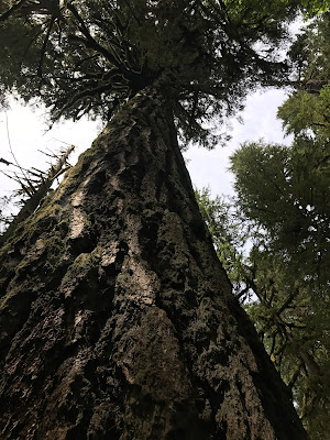
frequently to enjoy the wildflowers and the huge trees. You have to stop on
this sometimes-narrow trail to look up at the treetops. There are many rocks
and roots to trip you if you walk and gawk too much! So slowing down, or
stopping to have a look is recommended.
Tips
for Hiking the Salmon River Trail
(contains affiliate links)
Gear Up for Your Hike - You'll be more comfortable and safe if you have the following:
Gear Up for Your Hike - You'll be more comfortable and safe if you have the following:
- Water Bottle or Hydration Pack
- There are cliff face trails that are exposed to the sun and can get very hot.
Consider a small
hydration pack. The day was warm and there was shade, but it was still a
day to carry water.
- Lunch or Snacks
- Carry at least some trail mix or snack bar. The hike might take longer than
you think it will and a good trail bar or mix will give you energy. I prefer Corazonas
bars. They taste great and are a healthy snack.
- Hiking Stick or Hiking Poles
- Due to uneven terrain, rocks and tree roots, you'll need to consider a hiking
stick. I prefer my collapsible
travel staff. It gives me a third leg and helps a lot when I trip or slip
(which isn't uncommon for me!)
- Gortex Hiking Boots with Good Tread
- It's uneven terrain out there on the trail and it's rather rocking in places.
I like a mid-height
gortex hiking boot. If you want to get over to the island, waterproof boots
are a must.
On the way back, as I was ready to leave Sandy, I saw a sign for the Jonsrud Viewpoint and followed it off to the right. This is a favorite stop for photographers. You will enjoy spectacular views of Mt. Hood and the Sandy River Valley as well as informational signs about the Barlow Road, part of the Oregon Trail.


No comments:
Post a Comment